A few weeks ago, the publication of a study that I carried out with my colleague prof. Franklin Ramirez came out in the prestigious scientific magazine Cities.
The publication of this study represents an important professional achievement in the search for a tool for measuring a rather forgotten lack of urban life, public time. Often when talking about cities the most frequent term is public space, however for a space, along with its qualities, to be defined, it is necessary that it have the possibility of something happening there. So it is necessary to ask first of all, how much time do people have to live/make public space?
This is a first question that my research team asked ourselves, a few years ago, in the face of the considerable loss of daily time in the daily trips from home to work of the population residing in the large metropolitan area of San Jose, Costa Rica – however from any medium-large city in the world.
So the main objective of our study was to analyze whether in the GAM the population residing in more diffuse areas had a different availability of pubic time, compared to the population residing in compact and mixed areas.
Background.
Before delving into the details of our research, I’d like to take a moment to address a topic that has long fascinated and concerned me from a scientific standpoint. In recent years we have heard a lot about urban justice, however, what is different about urban justice from simple Justice as a general term? If I can give my point of view, it pertains to addressing a specific set of injustices that have systematically developed within urban environments.
Personally captivated by the social dynamics of the “civitas,” I recognize cities as vast and intricate crucibles of humanity’s challenges. They serve as focal points where various forms of injustice, inequality, fraud, neglect, and cynicism converge. It could be argued that cities serve as the birthplace of various injustices that extend beyond urban boundaries. Remote from urban centers, we witness the depletion of natural resources, deforestation, pollution from chemical dumping, and the displacement of populations from their lands. These actions often stem from initiatives designed to perpetuate urban expansion, catering to the incessant production and consumption of unnecessary goods.
Social and ecological injustices are intricately linked to the concept and management of common goods—resources like land, water, air, and food. Throughout history, the transition of these resources from common to private ownership has given rise to systemic injustices, including disparities in access to essential needs.
Today, we witness a subtler manifestation of this manipulation, particularly in urban settings. Millions of people endure daily struggles for basic necessities like shelter, water, and food, often traversing long distances and enduring monotonous work to sustain themselves in a consumerist society. This perpetual cycle of consumption perpetuates a debt to appearance, where individuals sacrifice genuine connection and community for the sake of superficial pursuits.
In the face of these daily challenges—long commutes, repetitive work, and compulsive consumption—the design and conditions of cities profoundly influence residents’ well-being and sense of community. Urban injustice, therefore, encompasses the deprivation of time to truly exist, to engage with one’s community, and to care for the urban commons.
In essence, urban justice demands more than just addressing material inequalities; it necessitates creating environments where individuals have the time and opportunity to thrive as active members of a caring and supportive community.
The Enclosure Acts (the laws with which the new money aristocracy expropriated state land from communities) “made Great Britain richer”, in the sense that British speculators accumulated ever larger masses of money.
focused on proposing an instrument for measurement of public time, as a time that people decide to use for the common good, and at the same time test said instrument in measuring the population of the great metropolitan area of San Jose. This measurement was carried out during the participation of architecture students in the LabGov Costa Rica Laboratory, where the group learned to carry out large-scale surveys and interviews, implementing at the same time the use of georeferencing tools (GIS) to record data on maps.
To achieve the objectives of the study, a quantitative methodology employing a descriptive and cross-sectional design was utilized. The investigation focused on analyzing the relationship between urban area types and their impact on public time usage, civic activism, and the Urban Civic Participation Index. Drawing inspiration from Frank et al. (2004), whose research revealed a higher obesity rate in neighborhoods with homogeneous land use, particularly in dispersed city models, this study sought to assess whether a correlation exists between public space utilization, or more broadly, the availability of public time, and residential areas.
The study encompassed a population of 240,000 individuals commuting daily within the Greater Metropolitan Area of San José during 2018, based on data compiled by the Inter-American Development Bank. Through intentional sampling, 572 participants were selected, evenly split between residents of Zone A and Zone B. This sample size exceeded the established minimum requirement of 384 participants, ensuring a representative sample with a margin of error of 4.09%. The research commenced with a characterization of the two urban areas under scrutiny, delineating differences in compactness, land use, and population density.
Conclusion.
After examining the data, some intriguing differences came to light between the people living in Zone A and Zone B. Notably, in Zone B characterized by a compact, mixed-use, and medium-density urban layout, inhabitants experienced shorter daily commute times, demonstrated higher utilization of public spaces, and declared being more involved in community activities. Interestingly, despite comparable availability of free time between the two groups, Zone B residents allocated part of their time to civic and community activities associated with public spaces, indicating a distinct lifestyle preference shaped by the urban environment.
While this study doesn’t establish causality, it hints at the impact of commuting times on individuals’ rest and meal hours. Given a standard 9-hour workday, disparities in commute durations between the two groups could result in over an hour difference in rest time, favoring residents of Zone B. Plus, individuals in Zone B displayed a propensity to dedicate their daily resting periods to public-oriented activities, suggesting a preference for community engagement over individual leisure pursuits.
The findings hint that urban models influence the allocation of personal time and lifestyle choices, potentially exacerbating stress and promoting a frenetic lifestyle, as noted by previous researchers. Further investigation in behavioral economics and time-geography could provide deeper insights into this phenomenon, particularly regarding inequalities perpetuated by urban models. Additionally, exploring the values and beliefs guiding residents’ choices in urban environments could shed light on what drives our choices and values in the places we call home.
Addicted to being carried along [the habitual passenger] has become impotent to establish his domain, mark it with his imprint, and assert his sovereignty over it. He has lost confidence in his power to admit others into his presence and to share space consciously with them. […]
He comes to believe that political power grows out of the capacity of a transportation system, and in this absence is the result of access to the television screen. […]
He has lost faith in the political power of the feet and tongue. As a result, what he wants is not more liberty as a citizen but better service as a client. – Illich, 1974, p.9
Relationship between the city model and the other study variables.
Dependent variables in the survey.
Daily activities according to the 2017 National Time Use Survey, own elaboration.
In November 2023, I had the pleasure of presenting a talk at the VII Ecuadorian Congress on Urban Studies, where I introduced elements of the concept of co-city to this Latin American audience for the first time. Within the framework of the session on participatory processes and methodologies, I presented the Lecture titled “From Smart City to Slow City: Co-creation Protocols in Asia, Europe, and Latin America”. The intention was to showcase some case studies of cities that have been promoting the co-city model, both in Italy and Costa Rica, preceded by an overview of the situation of cities in Asia that have embraced the smart city model.
The primary aim of this approach was to compare the two models and highlight the advantages of a citizen-centric approach in the Italian and Costa Rican contexts vs the hyper-technologized model of the smart city in Asia by Ken Fallas, MSc.
Background
The congress was organized by the CIVITIC network and the Universidad Estatal Amazónica. The CIVITIC network was established following the HÁBITAT 3 ALTERNATIVO (H3A) event, held in Quito in October 2016, in response to the need to continue articulating alternative dialogue spaces after Habitat 3. To date, it has organized 53 thematic panels, 6 national congresses, 5 research seminars, 7 film and city exhibitions, 7 citizen forums, and 6 special issues on Ecuadorian urbanism in specialized journals.
The presentation took place within the framework of the session on Spaces of Identity and Participation facilitated by Professor Ekaterina Armijos Moya and Verónica Mena Granda from the Pontifical Catholic University of Ecuador. This conversation was previously opened by a pre-conference panel moderated by Architect Gonzalo Hoyos, featuring María José Carrasco from the Pontifical Catholic University of Ecuador, Leticia Lozano, and Daniel Sardo from the Jesuit University of Guadalajara. They discussed the importance of local knowledge and the preservation of cultural identity in the collaborative construction of spaces and real experiences, aiming to generate proposals that enhance quality of life and foster social innovation.
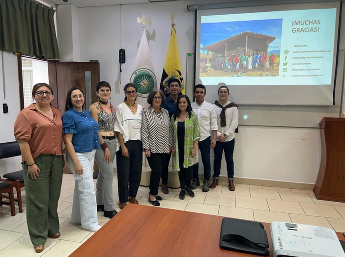
The architect Isadora Hastings from Mexico introduced the topic with a keynote speech on “Spaces of Identity and Participation in the Context of the Climate Crisis.”
She is the founder and director of the organization Cooperación Comunitaria (https://cooperacioncomunitaria.org) and has extensive experience working with rural communities in Mexico, learning from them to ensure the fulfillment of human rights to life and habitat and for socio-environmental justice.
Personal participation
During my presentation as an international speaker, I delved into the topic of “From Smart City to Slow City: Co-creation Protocols in Asia, Europe, and Latin America,” focusing on several topics relevant to the conference context.
Firstly, I discussed the Italian background, where I examined the concept of the city as a common good and introduced the framework of the co-city. I emphasized the innovative approach to reimagining urban spaces in the 21st century. Furthermore, I analyzed Italy’s experience in implementing the city as a common good, particularly highlighting the regulatory measures for citizen collaboration. I provided a specific case study from Reggio Emilia to illustrate the concept of enabling urban commons.
Moving on to the application of these concepts in Costa Rica, I highlighted the notable growth of urban activism in the country from 2012 to 2022. This period witnessed significant contributions to the city’s transformation. Additionally, I explored the utilization of Information and Communication Technologies (ICTs) in facilitating bottom-up actions for the regeneration of common goods. I focused specifically on the city of San Jose as a case study to illustrate these concepts in practice.
In the case of San Jose, it is important to highlight how the stakeholders involved in this new city governance model have managed to collaborate before the introduction of a regulatory framework for managing urban common goods. An example of the introduction of this concept in Costa Rica is with the Municipality of Alajuelita, with which a project to survey urban commons has already begun through the creation of a georeferenced database, in collaboration with graduates from the Universidad Latina de Costa Rica.
In conclusion, the presentation suggested reflecting on the importance of public time and an ecology of attention; as well as bottom-up management, with spaces for improvisation and spontaneity
It was particularly important to present this model within the framework of the Ecuadorian conference, as it provided an opportunity to showcase innovative approaches to urban development in diverse contexts. Additionally, by presenting cases from two continents, I aimed to bridge experiences from Italy, Costa Rica, and Latin America, enriching the conference program with cross-cultural perspectives.
My goal was to encourage attendees to explore new avenues for urban innovation and learn from global best practices, ultimately fostering a more collaborative and inclusive approach to urban development. Furthermore, the objective of the co-city model aligns clearly with the concept of thinking globally and acting locally, as well as with the vision of the Quito Manifesto for city-making by H3A (Toward an Alternative Habitat 3) and the GPR2C, which is not so much about urbanization but rather about answering the question of how to govern the territory in a fair and democratic manner.
Conclusion
Being able to participate in such an event has been an honor, as these occasions are always enriching opportunities to share perspectives and build connections among professionals from all countries who are interested in promoting solutions for fairer cities at different scales and in different environments. Specifically, the Latin American territory is particularly rich in experiences that open our eyes to the urgency of bottom-up innovation, with scarce resources but an infinite desire to act and solve problems. This type of space also generates high expectations, personally about the importance of creating links between the global South and North.
Finally, the call for a slower city, in contrast to a fast one where citizens are nothing more than data flowing on servers, is the foundation for people to feel part of their communities and alongside them, as peers, to build a true and fair commons governance.
Coordinator team of the thematic axis “Spaces of Identity and Participation” (PUCE), with members from Cooperación Comunitaria of Mexico. Rights to the photo of the university and the organizers.
Isadora Hastings keynote speech. Rights to the photo of the university and the organizers.
Conference participants. Rights to the photo of the university and the organizers.
Urban commons are essential to the vitality of any city. They serve not only as public spaces but also as catalysts for local development and technological innovation. This allows for greater transparency in budget execution and information sharing about community-owned spaces. The residents of a city play a critical role in shaping its dynamics, and it is vital that they have access to knowledge about these shared spaces.
At the end of 2022, the School of Architecture at Universidad Latina conducted research with a local government in the Greater Metropolitan Area of the capital of Costa Rica. Thanks to the research coordination of the architecture department and the effort of a final year student, a community’s urban commons were studied for the first time. This achievement led to the mapping of these urban commons and initiated collaboration with a Costa Rican municipality in potentially applying this concept.
The study focused on the Alajuelita canton in Costa Rica, which encompasses a territory spanning 21 square kilometers. Within this area lie 120 parks and playgrounds that are considered urban commons and receive maintenance on their green spaces from the local government. Upon closer observation of these areas, it became apparent that they had been subject to social abandonment and insufficient planning. This gave rise to the development of a guide aimed at addressing these issues. To this end, the proposal recommended a geospatial and digital survey of each location through the use of a diagnostic form.
Background.
The limited planning in previous administrations and the restricted budget, according to the Municipal Management Index 2014 (General Comptroller’s Office of the Republic, 2014), resulted in common goods not meeting maintenance standards, thus causing high percentages of citizen insecurity, local development lag, and social segregation in communities.
In previous years, Alajuelita reported low levels of human development due to a lack of local planning. However, these indices have been on the rise thanks to the good management of the current administration (2016–2024). In 2006, the index was 0.839, and by 2016, it had increased to 0.923, according to the United Nations Development Programme’s Human Development Index (2006–2016).
The research and guide were aimed at creating a roadmap that would enable the conversion and implementation of public spaces in the medium term. The commitment of local governments to achieve the SDGs was kept in mind while identifying the problems that had arisen in these public spaces.
Problem statement.
All of the urban commons in the canton lacked a diagnosis or study of their land, furniture, green spaces, or gardens. Additionally, there was no assessment of accessibility, uses, or actors involved in civic engagement by residents. From this, the research question was raised: How to promote civic participation and political activation through the dissemination of data on the conditions of existing common goods?
Justification.
Costa Rica has received various proposals for the utilization of public spaces with different types of technological implementations, some of which have been successfully implemented. As part of the Digital Transformation Strategy, in 2019, the Ministry of Science, Innovation, Technology, and Telecommunications (MICITT) inaugurated the Connected Public Spaces Program. This program was funded by the National Fund and aims to provide access to free Wi-Fi in public spaces across Costa Rica. The implementation of this program is expected to have a significant impact on the accessibility and connectivity of citizens, particularly those who may not have access to these resources at home. Additionally, this initiative is anticipated to benefit local businesses by increasing foot traffic in public areas.
The research proposed the general objective of developing an Analysis Manual for the application of civic technologies that enabled political activation in the urban commons of the canton. This objective was to be achieved by 2022, through the dissemination of data and social, environmental, urban, and community interaction. Specific objectives were also raised, as follows: 1. Conduct a survey to locate common goods in a GIS-type archive. 2. Deepen topics with an interdisciplinary approach such as law, economics, engineering, and social sciences to strengthen the development of civic technologies.
Research Design.
How to promote civic participation and political activation through the dissemination of data on the conditions of existing common goods?
The research approach was mixed, as the solution to the problem posed involved diagnoses and studies that delimited and indicated how common goods should be. This was not only in the implementation of technologies, but also in the implementation of new strategies for citizen and political participation.
The variables that were analyzed in the study included civic citizen participation (qualitative, dependent), methodology for the use of civic technologies (quantitative, independent), and an inventory of workshops, talks, trainings, and activities generated that could be given in an urban common (qualitative, dependent).
Results.
The surveys and interviews that were conducted provided crucial data that allowed for the utilization of information. Based on this, an analysis manual was developed for the application of civic technologies. Its goal was to analyze common goods from various perspectives, proposing uses, technologies, and innovations.
Discussion.
After the analysis was carried out in the territory, and the common goods were diagnosed as children’s play areas and parks, it became even more clear that these commons had a significant need – not only in this canton but also in most others.
Beyond urban planning or comprehensive community projects, citizens have the right to enjoy these spaces, and local government must provide security, a healthy physical environment, well-being, development, democracy, and many other things that make up civic participation.
The transparency of data is an essential tool for the residents of the territory. How can we defend this right when we are unaware of our city? Unfortunately, this is what is experienced outside in the neighborhoods and parks. Our greatest task as privileged citizens is to share, propose, and seek to execute collective well-being.
Conclusions.
The urban commons, as a vital part of the city, deserve to be used in a way that is fundamental to the social, economic, cultural, physical, and urban development of its citizens. Alajuelita is a canton in full socio-economic development that has required understanding its territory from the most essential aspects. For this purpose, it was necessary to develop the tools so that the local government could begin a process of physical regeneration.
This study acknowledges the collaboration of Keily Mena Alfaro (author of the thesis), the Municipality of Alajuelita (Costa Rica), and the Municipality of Valladolid (Spain).
The project “Live close to home: a projection of a compact and responsive city for the central neighborhoods of the capital San José.” aims to propose a dense, compact, mixed city model that makes intelligent use and fair access to resources (soil, water, air) as a commons, to promote healthy, dignified lives for its inhabitants, and which reduces the impact of the effects of climate change. The project proposes to break with the city-countryside duality without falling into mistakes already made by other architects (eg, garden city) who proposed low densities and sectorization. It also meets the guidelines of the SDGs and the concept of the City as a Common Good.
The proposal was elaborated for the mega-block #11 in downtown San José, following these guidelines: A. Use of rainwater (thinking about climate change, flood/drought scenarios) B. Application of the concept of agroforestry (agricultural production in coexistence with forest for the livelihood of the neighborhood) C. Traditional proximity commerce, together with spaces for new jobs (spaces for teleworking, in co-working that integrate nurseries, libraries, municipal entrepreneurship accelerators, etc.)
This project participated in the international call for proposals of the Seoul Biennale of Architecture and Urbanism 2021, entitled CROSSROADS Building the resilient city.
[Project Location: Between 20th ave. and the 14th ave. and 10th street and the 2nd street, in the southern area of the San José downtown, Costa Rica.]
Our goal for this year 2020 stage in the process of the Social Housing as a Commons project was to develop a strategy that could reevaluate landscape planning based on the redefinition of the parameters of urban life. This, proposing a more efficient and functional urban space, with reduced ground coverage, for the basic living and development spaces, which at the same time would represent a possible model to be developed in the future in other areas of the city that also suffered from inadequate planning, which manifests itself with phenomena of accelerated overcrowding and abandonment at the same time.
The compilation of information is an arrangement of parameters to analyze the economy, business, lifestyle, and overall usage of the common spaces. These parameters provide a broad look at the problems within community relations, which need to be countered against inadequate planning that does not address their needs.
The need for intervention in these spaces could also be addressed from the impact for its inhabitants, which would translate into the capacity of a new local economy based on a sustainable and empowered community, recognized for its sensitivity to the environment and a better sense of community experience.
Therefore, a strategy was proposed to intervene in a city area that suffers from inadequate planning caused by the accelerated overcrowding and abandonment in this specific area of San Jose, Costa Rica. This generally affects the population of the area, due to problems of access to affordable housing in their neighborhood and daily living in a highly polluted environment. Having an overcrowded population is a common problem in several cities. But the main issue is what this indicator of overpopulation does to a space that wasn’t ready in design for it.
The first marker is the inadequate planning of these areas that are visible in the unplanned streets and roads and the progressive growth in the use of vehicles in the city. The collapse of the different routes is just a small component of the overall issue. The lack of confidence in public transport linked to a not deeply rooted culture of it clearly translates into an excess of gas emissions for the capital.
Another pattern is the presence of redundant and little varied commerce in an area where there is no economy based on strong local products and where more generally there is a lack of areas for socialization. We observe a forgotten place, where the general economic activities are the result of a community without real empowerment.
These two markers are the representation of a society in need of urban intervention to give these communities the necessary infrastructure to rehabilitate.
Dragging the problems of overgrowth, for a community that has been neglected by public policies, has caused a fracture of the urban system and, at the same time, the dissociation of the resident community. Because its local commerce is not varied enough, the economy in this area is static as well as its community that lacks social and cultural spaces to develop a well-built sense of community. The overall planning and infrastructure of this sector require a change to develop a strategy that gives this population affordable housing in a thriving environment.
For the development of the proposal 3 mega blocks were chosen previously zoned where each of them has dynamics particular social networks that make them function as such. The choice of the blocks was made through an analysis to determine which were the areas with the greatest urban potential, diversify the uses for the development of different proposals that can have a positive impact on the site and be able to evolve the conceptual programming by means of a physical spatial design.
The design of an urban conception is part of a strategy that goes along with projections and indicators that parametrize the design to have a successful intervention in a long term. These strategies of intervention would give the right infrastructure to these communities, planned roads to give pedestrian mobility by proximity. The main modulation of the building spaces is fundamental through a multi-position floor array building, and by acknowledging the revalorization of cultivation spaces and the hydrology mechanisms that it needs to thrive in the city to form a dynamic society and a new local business income. The new infrastructure will be able to provide heterogeneity for the local commerce to have local and cultural products with a stronger sense of nationality that will propel the economy.
We look for a better way of living in the city and at the same time, we deal with the problems that modern life brought us. Concerned about traffic and pollution, we need to create a system to get closer to a real urban solution for a problem that concerns us today but is growing unsustainably day by day.
Regular communication with the community is an important need to have a broad vision of the problems of the context. For this project, we set out to know the customs of the neighbors with respect to their environment, the people who characterize the neighborhood, and the rhythm of daily activities was the key to a contextualized project.
The planet demands that we listen to it. For this, we also have to give a voice to the people who demand a better standard of living. The quality that architects, urban planners, and decision-makers can provide to the Social Housing and its immediate context is the basis for change.
CROSSROADS Building the Resilient City CALL FOR PROPOSALS SEOUL BIENNALE OF ARCHITECTURE AND URBANISM 2021
The following article presents the work of discussion between two hypotheses born within the academic research that was developed throughout the Urban Design courses. The focus of these classes allowed to discuss and analyze the possible influences of urban planning on the phenomena of experiencing public space, as well as citizen public time. On the one hand, the relations between the various concepts to be studied in global terms were underlined, on the other hand a specific reading of the phenomenon was proposed in Costa Rica. These approaches were developed through qualitative research based on the literature review of sources that also provided the opportunity to design an investigation aimed at dialogue between the documents. The critical-historical approach sought to construct a theory that could narrate the Costa Rican idiosyncrasy in the field of urban experience, between its tangible aspect of “public space”, as well as its socio-cultural and political counterpart, defined as “public time”.